Roaming the Western Ghats
My travel experience in the Western Ghats of the Shivamogga district
03 Sep 2022
Recently, I had to travel to Shivamogga, which is located at the plains of the Deccan Plateu. From there, instead of returning home directly, I travelled the Westren Ghats of that district. In this article, I will take you through my journey.
The Road to Shivamogga
The route from my native Kalasa to Shivamogga takes us first through the base of the core Westren Ghats, and then through a tail of Chandradrona mountains of Chikkamagaluru. The route transitions from mountainous, to the paddy fields and then back to mountainous, before finally yielding to the plains of Shivamogga. The route offers the view of small hills and dense semi-evergreen forests all along the way, which are full of green during the Monsoons. Intercepted with them, there are paddy and areca plantations.


Banana, Areca and the Forest
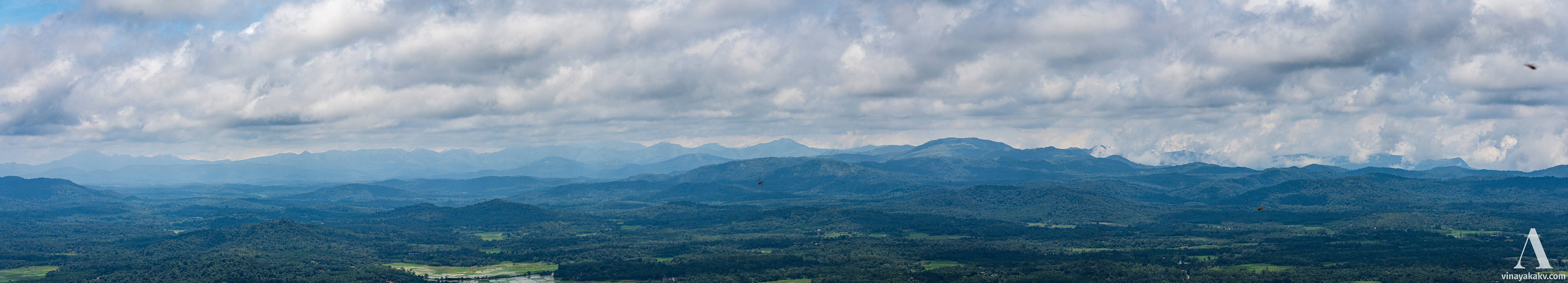
The route passes beside the Bhadra reservoir, which I could not photograph as I was sitting at another side window of the bus .


Bhadra reservior at left, as viewed from a distance. At the right are the two tail ends of Chandradrona
We also encounter numeorous medium-sized lakes, which are unusual at my native, as the terrain there is much hillier.


A roadside lake with cloud-capped hill
At Shivamogga, we are at the plains with around 600m elevations, which means we lost around 200m elevation without ever noticing!
Back to the Mountains (Hills?!)
We decided to travel to Jog waterfalls from Shivamogga, which is located around at 90km Northwest of it as the crow flies. In the route, we get to see numerous lakes, this time without any hill to provide a backdrop! We also see power grid lines, which supposedly distribute the hydal engergy generated at Linganamakki reservoir, which is built across the river Sharavati, which creates the waterfall at Jog.


A lake with power lines, notice the terrain there is not so hilly
Situated around an elevation of 488m, the water falls an elevation of 253m to a deep valley. We were greeted by rains the view was covered with mist all along! Fortunately, the rains stopped and the mists cleared within half an hour, revealing the roaring water behind. Since the fury of the monsoon had reduced and the reservioir gates had been closed, the waterflow was less. Some streams would get barely noticeable during the summers.
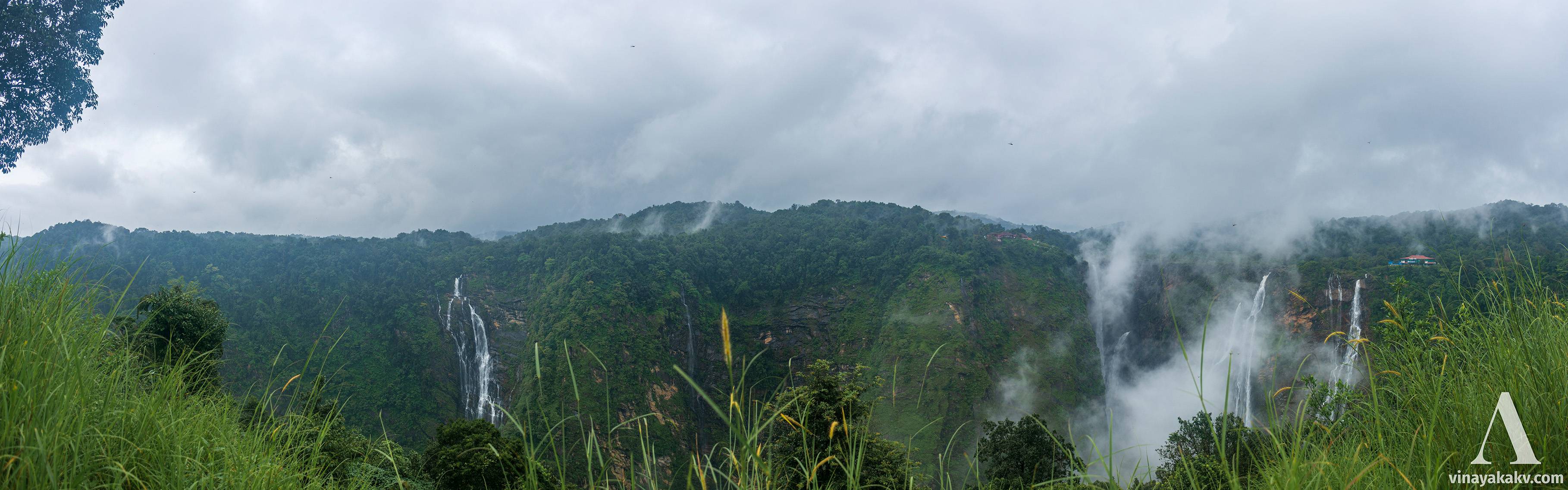
View of the Jog waterfalls, the main streams are at the right, however there are numerous streams apart from them.
The faces of the rocky slopes there are covered with forest wherever there is abundent soil available, otherwise with moss-like plants.


A rock face at Jog, with forest at top, and mosses and other plants at bottom. That star-like plant at the bottom is interesting, maybe it is Rock banana
If you take time to roam around, you can see other waterfalls, which make a beautiful sight along with vegetation.


A side-stream at Jog
You can also see waterfalls in surrounding hills, few near and others far.


A long waterfall at nearby hill, notice the power wires and a tower at the top
The waterfalls in the far away hills can be clearly seen if they not covered by mist.


A waterfall in a far-away hill near Jog
Even if the mist is to blame for obstructing the view of the waterfalls, they create beautiful scenes on their own, playing with the rocks surrounding.


The main stream "Raja" of jog covered with mist
Near the waterfalls, there is also a small power generation facility, which sources the water from a nearby reservoir.


A power generation facility near Jog, notice the pipes carrying water at bottom-left
While entering the waterfalls, we come across the Sharavati bridge, after flowing through which the river falls into the deep valley. Near the bridge, you can neither guess the depth of the valley, nor the flow of water as everything seems plain and silent there!


The Sharavati bridge. To the left, there is waterfalls
To the Coast, and back to the Mountains
After Jog and back to Shivamogga, I descended the Ghats at Agumbe and entered the West Coast. The route to Agumbe from Shivamogga passes through beautiful forests and Gajanur reservoir built across the Tunga river, which I could not catpure as I could not get a window seat in the crowded bus . I also missed a beautiful sunset amidst light rain at Agumbe Ghat road due to camera not focusing well . To compensate for these losses, I decided to come back the next day! The hills of the Agumbe Ghat look magestically covered with green from the Someshwara, where the ascend starts.


Hills of the Agumbe Ghat with broad-crowned trees lit-up
The forests of Agumbe are protected as reserves. Among their rich flora and fauna, one can easily spot varaities of monkeys.


A Langur
Out of the monkeys there, the Lion-tailed macaques are endangered.


A Lion-tailed Macaque
The Agumbe ghat is convoluted and has 14-hairpin curves. The route at lower elevations is covered with dense forest.


The ghat route covered with forest
As one ascends the ghats, the density of the forest decreases, sometimes providing a clear view of the coastal area below.


At higher elevations, the forest is less dense
After the full ascent, there is a viewpoint, which unfortunately was covered with mist. However, we can enjoy the Cloud Forest vibes, with moss-covered trees.


A moss covered tree branch
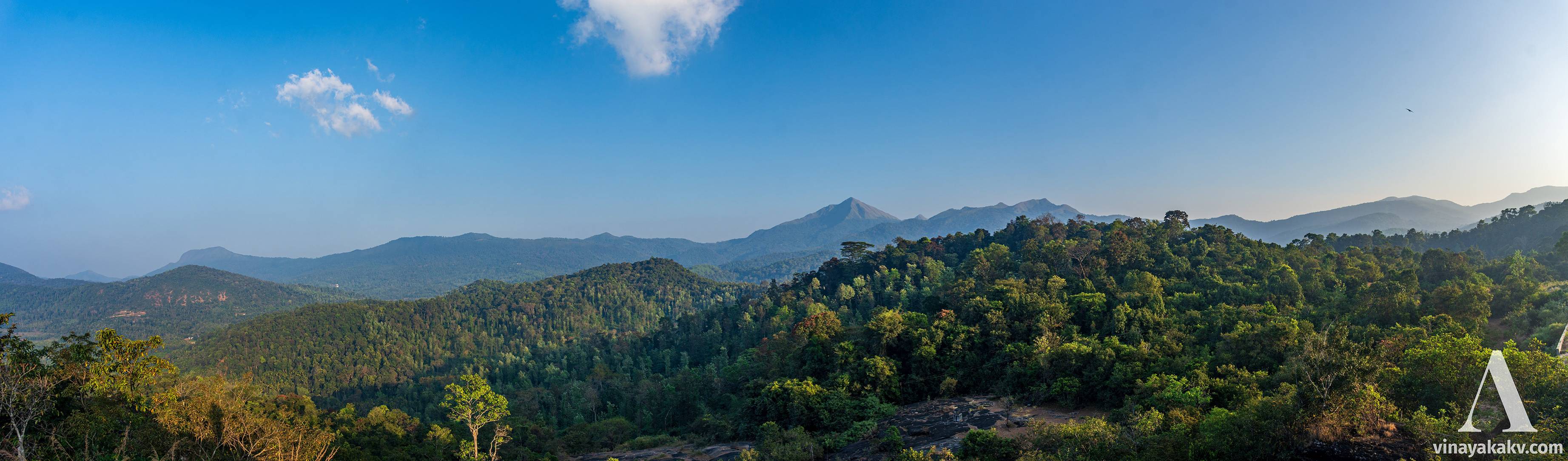
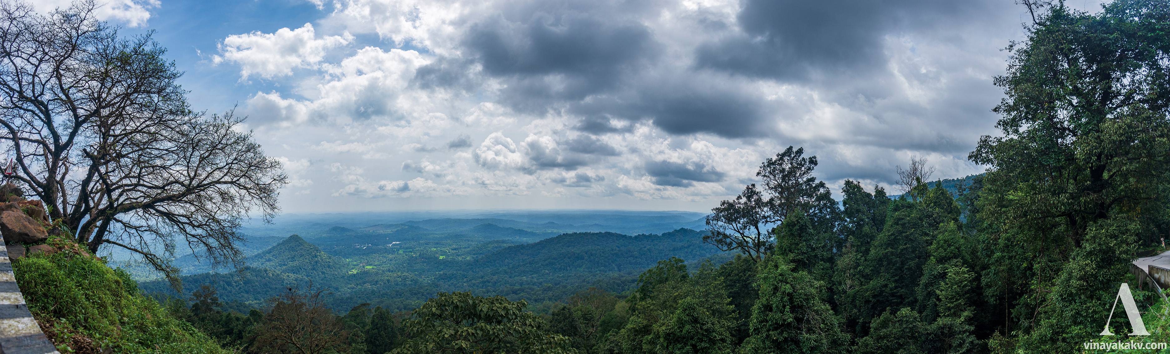
After we ascend the ghat, the mountains give way to small hills, and dense tropical forests turns into to vast paddy fields. Out of the hills near Agumbe, Kundadri (976m) offers a view of surrounding villages and distant Kudremukh mountain range on a clear day, as it raises around 300m from its base.


Kundadri, the rock hill behind, from its base
Sighting Faraway Mountains
As we enter Kundadri, to the south, we see high Kuduremukha range. The sharp peak of Merti Parvata (1663m, 37km LOS) is identifiable easily if it not covered with mist. You can remember me sighting it from Mudigere, from 36km LOS, which is around the same distance. However, the line from Merti Parvata to Kundadri is less mountainous, permitting for a clear view.


Merti Parvata from Kundadri. It is the highest point in this picture. You can also see all its 5 peaks, which is quite confusing to count as there is another mountain with sharp peaks just right to it.
For the reference, here is a similiar view of Merti Parvata, taken from a much nearby hill.
Merti Parvata is at the center, with 2 peaks visible. Another sharp peaked mountain is at its right.
Then, we can see the route from which we came, which is easily identified by a giant tower atop Agume ghat.


A view of Agumbe Ghat tower
We also see a sharp peak of the Kuduremukha Range (there are two, actually, one is covered with mist here) descending to Kabbinale.


A Sharp peak at right descending to Kabbinale
We also see the Kuduremukha Peak (1898m, 49km LOS) itself, which unfotunately was covered with clouds. Then, moving on to the right, we see Thulajankal Motte (1441m, 32.6km LOS), Kadamadi Kallu (1494m, 45.2km LOS) and Gangadi Kallu (1426m, 33.6km LOS) mountains in order. Remember their names, we will come to them later!


A view of Kuduremukha range from Kundadri
We could have seen Valikumja as well, but its surroundings were covered with mist, which too was a beutiful view .


Misty mountains near Valikumja
To the Northwest, we see the backwaters of Mani reservoir, along with a view of Kodachadri mountain (1376m, 46km LOS).
Mani resorvoir, Kodachadri is at center-left, covered with mist
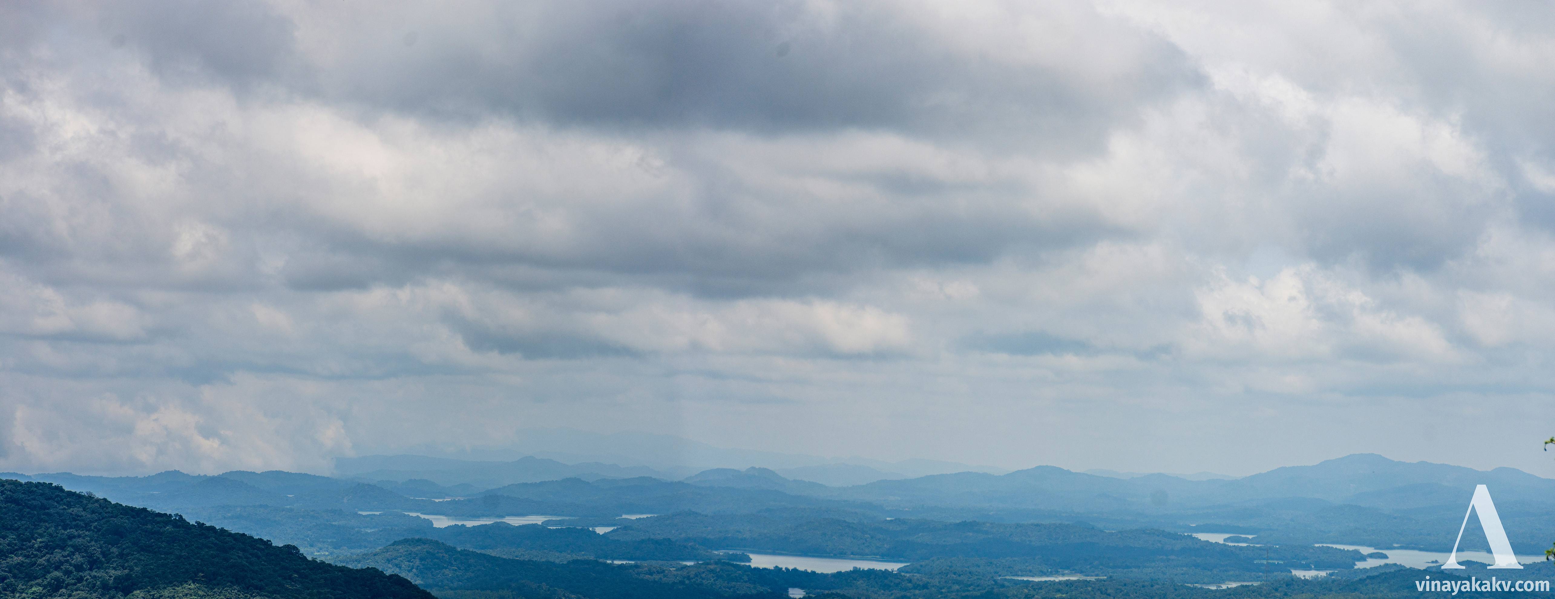
All these sightings are possible only if the air is clear, and the sky is cloudless (which was not when I visited!). Otherwise, all you can get is a good view of its base.
View from Kundadri on hazy day. The photo is processed to make the effect of haze appear less. The tower of Agumbe ghat is at the center of the photo and barely visible.
Although it was cloudy the day we visited, we could still get a nice view of the Kuduremukha range. Chandradrona range of Chikkamagaluru should have been ideally visible, but it was covered with clouds.
Panorama of Kuduremukha range from Kundadri. We start with Merti Parvata at left, peaks near Kabbinale at right. At center-right, we see Narasimha Parvata of Kigga.
Kundadri is also under an in-situ biodiversity conservation plan. We see some nice shaped trees covered with mosses atop it.


A moss-covered tree atop Kundadri
Apart from Kundadri and its surrounding hills, the way forward from Agumbe to Shivamogga is mostly flat. Thus, we head back towards the Ghats, but this time a different one.
Back to the Ghats - Hulikall
The route from Agumbe towards Mastikatte, where the Hulikall Ghat starts, is hilly.


A hill along the route towards Mastikatte
We also get to see backwaters of the Mani reservoir often, whose purpose is again to generate electricity.


Backwaters of Mani reservoir
Once we reach Mastikatte, the descend begins. We get a temple along mid-way, near which we get a beautiful view of the coast below.
A view from Hulikall Ghat
Kodachadri is also visible from here, hidden behind serveral hills. For us, it was convered with clouds and we could barely see a part of it.


Kodachadri is at center-right, barely visible behind a gently slopped hill, covered with clouds
Another attracting view is of Mettkall hill, atop of which there is a temple dedicated to Ganapathi, which is painted in bright orange.


Mettkall hill and the temple above
The descent of the ghat is very gentle, which is very much opposite to that of the Agumbe Ghat; thus, heavier vehicles tend to choose this route, making the road condition generally not good. Once we descend the ghat, we enter Hosangadi and then Siddhapura, after which the route heads towards Kundapura, a town beside the sea. Instead, we choose to move back the foot of the Westren Ghats!
At the foot of the Westren Ghats
From Siddhapura, we moved towards Thombattu, which recently had become famous among the tourists for its numerous waterfalls. On the way, we came across backwaters (again!!) of a small reservoir (to generate electricity, again), with the heads of the dead coconut trees still visible.


Hand of the dead
At Thomabattu, the Westren Ghats greet us again. It was becoming cloudy by that time.


The Westren Ghats as seen from Thombattu
We ventured into a nearby forest to get a view of a small stream jumping from the rocks.


A small stream amidst forest
With the Monsoon, the Impatiens bloom on nearby rocks was a sight to behold.


One leafed Impatiens plants
Their structure is pretty attractive, with a single leaf and a flower.


Close-up of the Implatiens
Another notable plant I came across is thorny Areca-like plam, mostly known as “Rattan Palms”


Thorny Areca!
With the sun setting in and clouds getting darker, it was the time to end journey for the day.
Back to the Sholas
Ganesha festival lunch in and around the ghats of the Kundapura taluk is special — you don’t get any fried items; not even coconut oil to the side! However, you get a plenty of ghee . There is a belief that the ones eating fried items that day will become bandicoots in next incarnation . After enjoying the lunch there, I headed back to my native. The sky was dark and it started heavily raining amidst the route. I ascended Mala Ghat, which is in the Kuduremuka National Park. There, we start to see the Shola mountains again. The view of the Thulajankal Motte and the valley below from beside the road is breathtaking (remeber, we saw this mountain from Kundadri!). Motte literally means egg in the local languages, which aptly applies to the mountains because of bare head without any forest! There are numerous motte mountains moving south across the Westren Ghats!


A view of Thulajankal Motte, with shola - a grassland-forest complex
We also get to the base of Gangadikallu mountain en-route.


Gangadikallu mountain, from its base.
From there, it is an usual journey for me amidst the sholas and forest to my native. I travelled around 800km exploring the Westren ghats, seeing forests, rivers and waterfalls, reservoirs, and, mountains along the way.
Ending Notes
Anything that I saw more than mountains and forests in this trip are reservoirs, most of them specifically built for power generation. While they provide the clean energy, they also disrupt the surrounding ecosystem. We must research efficient ways to generate power at a small scale without disrupting the ecosystem.
The Westren Ghats I explored, although are not lofty as the Southren Westren Ghats and Sholas, they host deep tropical forests home to a rich biodiversity, which is threatened from time to time due to the power generation projects.
The Bhadra and Tunga reservoirs near Shivamogga are specifically built to provide water for drinking and agricultural needs of the plains. Some 10 years ago, there was even a proposal to build an upstream reservoir to Bhadra, agian to send drinking water to the plains. With the rainfall patterns now changing with climate change, the plains get harsh, unexpected rains damaging their crops and setting some historical records. Along with repenting for the losses, at least, we can now focus on reviving the lakes of the plain to harvest the rainwater.